
Garmin GPSMAP 67i
Garmin GPSMAP 67i is backordered and will ship as soon as it is back in stock.
Couldn't load pickup availability
Care information
Care information
Display general product information or specific product information using metafields.
Delivery and Shipping
Delivery and Shipping
Add some general information about your delivery and shipping policies.
Garmin GPSMAP 67i
Description
Description
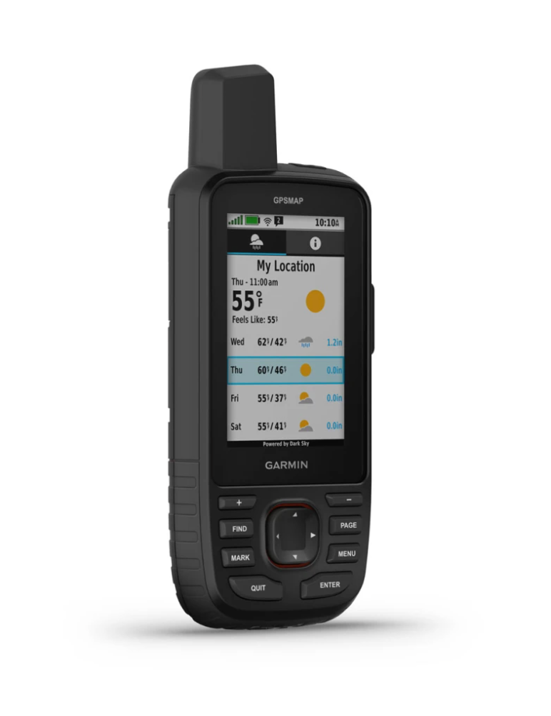
GO EXPLORE THE OUTDOORS — AND STAY CONNECTED TO HOME
Make more time for adventure with this premium, rugged GPS handheld and satellite communicator. Get inReach® technology that enables two-way messaging, interactive SOS alerts and location sharing1 plus mapping to keep you on course.
Travel longer with up to 165 hours of battery life in tracking mode and up to 425 hours in expedition mode.
Two-way messaging lets you share the moment with the ones who matter.
Let your loved ones follow your adventure with location tracking.
Have an emergency? Trigger an interactive SOS alert anytime, globally.
Track your position in challenging conditions with multi-band technology and expanded GNSS support.
BUILT FOR ADVENTURE
This handheld is built to military standards for thermal, shock and water performance (MIL-STD-810), and it’s even compatible with night vision goggles.
LED FLASHLIGHT
The GPSMAP 67 series helps you keep gear to a minimum with a built-in LED flashlight that can be used as a beacon to signal for help.
GEOCACHING
Get automatic cache updates from Geocaching Live, including descriptions, logs and hints. When connected via Wi-Fi technology or to the Garmin Explore™ smartphone app, each find will upload to your Geocaching.com profile.
General |
|
| Lens Material |
chemically strengthened glass |
|---|---|
| Dimension | 2.5” x 6.4” x 1.4” (6.2 x 16.3 x 3.5 cm) |
| Weight |
8.1 oz (230 g) with batteries |
| Water rating | IPX7 |
| MIL-STD-810 | yes (thermal, shock, water) |
| Display Type | transflective color TFT |
| Display Size | 1.5"W x 2.5"H (3.8 x 6.3 cm); 3" diag (7.6 cm) |
| Display resolution | 240 x 400 pixels |
| Battery type | rechargeable, internal lithium-ion |
| Battery life |
Up to 165 hours with inReach® enabled with 10 minute tracking |
| Memory/History | 16 GB (user space varies based on included mapping) |
| Interface | USB-C |
Maps & Memory |
|
| Preloaded maps |
yes (TopoActive, routable) |
|---|---|
| Ability to add maps | |
| Basemap | |
| Automatic routing (turn by turn routing on roads) for outdoor activities | |
| Map segments | 15,000 |
| Satellite Imagery | yes (direct to device) |
| Includes detailed hydrographic features (coastlines, lake/river shorelines, wetlands and perennial and seasonal streams) | |
| Includes searchable points of interests (parks, campgrounds, scenic lookouts and picnic sites) | |
| Displays national, state and local parks, forests, and wilderness areas | |
| External memory storage | yes (32 GB max microSD™ card) |
| Waypoints/favorites/locations | 10,000 |
| Courses | 250, 200 course points per course |
| Tracks | 250 |
| Navigation Track Log | 20,000 points, 250 saved gpx tracks, 300 saved fit activities |
| Activities | |
| Navigation Routes | 250, 250 points per route; 50 points auto routing |
| Rinex logging | |
